

For many visitors to Japan, their first glimpse of the country is the sprawling urban landscape of Tokyo. It can be hard to imagine what lies beyond the seemingly endless miles of concrete, electricity lines, konbinis and train tracks. Japan’s capital is inconceivably vast but the true amazement comes with the eventual realisation that it’s but a grain of rice in the bowl that is the country’s immense natural landscape. If you want to get to know the landscape of this naturally stunning nation, pulling on a good pair of walking boots and getting out there on foot is one of the best ways to do it. If you are of the adventurous penchant and want to move beyond the tried and true hiking trails of Mount Fuji (富士山), Jetpac eSIM will make sure you have reliable data for all of your researching, communication and location needs, no matter how far off the beaten track you wander. So, as inspiration, here are 10 alternative hikes to inspire you to explore Japan more widely.

Ten Japan Hiking Trails Beyond Mount Fuji
- Mount Fuji’s 2026 Climbing Rules: a ¥4,000 Fee and a 2pm Cut-Off
- Ten Hikes Compared: Where, How Long and When
- 1. Yakushima: Kagoshima Prefecture
- 2. Wazuka: Kyoto Prefecture
- 3. Mt. Mitoku: Tottori Prefecture
- 4. Kumano Kodō Pilgrimage Trail: Mie, Nara and Wakayama Prefectures
- 5. The Koyasan Choishi Michi Trail: Wakayama Prefecture
- 6. Michinoku Shiokaze Coastal Trail: Aomori, Iwate, Miyagi, and Fukushima Prefectures
- 7. Kunisaki Peninsula: Ōita Prefecture
- 8. Daisetsuzan National Park: Hokkaidō Prefecture
- 9. Mt. Tanigawa: Gunma Prefecture
- 10. The Seven Waterfalls of Kawazu: Shizuoka Prefecture
- Questions About Hiking in Japan and Climbing Mount Fuji
Mount Fuji’s 2026 Climbing Rules: a ¥4,000 Fee and a 2pm Cut-Off
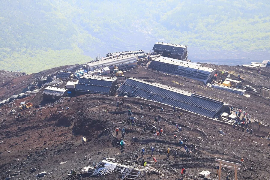
Climbing Mount Fuji now comes with rules that apply on all four trails. The official Mount Fuji climbing website, run by the council of the national government and Yamanashi and Shizuoka prefectures, sets them out:
- A ¥4,000 fee per climber on every trail, paid as a toll and entry charge.
- No entry between 2:00pm and 3:00am, unless you have a booking at a mountain hut.
- Online registration before you climb. This is separate from booking a hut.
- Kit checks. Hiking boots, waterproofs in two pieces and warm layers are required and may be checked at the start.
The trails are open only in summer. In 2026 the Yoshida and Subashiri trails opened from 1 July to 10 September and the Fujinomiya and Gotemba trails from 10 July to 10 September. Outside those dates every route above the fifth station is closed, and the official site calls a climb out of season extremely dangerous. If those crowds and rules are not for you, the ten hikes below spread across the year and the whole country.
Ten Hikes Compared: Where, How Long and When
| Hike | Prefecture | Time on foot | When to go | Good for |
|---|---|---|---|---|
| Yakushima: Jomon Sugi from Arakawa | Kagoshima | 9 to 10 hours return | Arakawa trail bus runs 1 March to 30 November | Ancient cedar forest |
| Wazuka tea fields | Kyoto | Short walks of your choosing | First flush picking from late April | Gentle walking and tea |
| Mount Mitoku and Nageire-do | Tottori | Climb must be finished by 4:30pm | Usually closed December to March and in rain | A cliff temple reached by chains |
| Kumano Kodo | Mie, Nara and Wakayama | A day to two weeks, by route | Year round | A UNESCO pilgrimage route |
| Koyasan Choishi Michi | Wakayama | About 6 hours 30 minutes, 21km | Year round | Stone markers and temple stays |
| Michinoku Shiokaze Trail | Aomori, Iwate, Miyagi and Fukushima | Sections of a 1,000km route | Check the trail website for section closures | Clifftop coastal walking |
| Kunisaki Peninsula Minemichi Long Trail | Oita | About 135km in ten courses | Check the trail website for course conditions | Rock-carved Buddhas and ridges |
| Daisetsuzan National Park | Hokkaido | Ropeway plus summit hikes | Summer, roughly July and August | Volcanic peaks and alpine flowers |
| Mount Tanigawa | Gunma | A day, with the ropeway | Ropeway runs mid April to mid November | A high peak within reach of Tokyo |
| Kawazu Seven Waterfalls | Shizuoka | About an hour one way | Year round | An easy waterfall walk |


1. Yakushima: Kagoshima Prefecture

Situated two hours by boat off the coast of Japan’s southernmost main island of Kyushu, just getting to Yakushima, which in 1993 became one of Japan’s first two natural UNESCO World Heritage Sites and is one of the country’s most remarkable islands, is an adventure into the backroads of Japan. Dense primaeval forests, gushing waterfalls and granite cliffs are the hallmarks of the place that inspired Hayao Miyazaki’s Princess Mononoke. Despite its popularity among Japanese travellers, this fantastical isle is less well known to international tourists, partly because it can pose a bit more of a challenge for visitors who do not speak Japanese. To make the most of your visit, local guides such as Yakushima Experience can be a huge help. Yakusugi Land is one of the most accessible spots for hiking on the island. This nature park covers roughly 270 hectares at between 1,000 and 1,300 metres above sea level, with walking courses from 30 minutes to a few hours through forests of ancient Yakusugi cedar. Entry is a ¥500 donation for visitors of high school age and over. With some luck, you might spot a yakuzaru monkey or a yakushika deer, both native to the island. Another great hike is the Arakawa trail to Jomon Sugi, a giant cedar often described as Japan’s oldest tree, with estimates of its age ranging from around 2,000 to 7,200 years. The round trip from the Arakawa trailhead takes nine to ten hours, so hikers set off between 5am and 7am. From 1 March to 30 November private cars cannot drive to the trailhead, and hikers take the Arakawa hiking bus from in front of the Yakusugi Museum instead.
Getting there and when to go: Boats from Kagoshima take two to four hours, and flights about 40 minutes. From 1 March to 30 November the Arakawa trailhead is reached only by the hiking bus from the Yakusugi Museum, so plan your Jomon Sugi day around its first departures.
2. Wazuka: Kyoto Prefecture
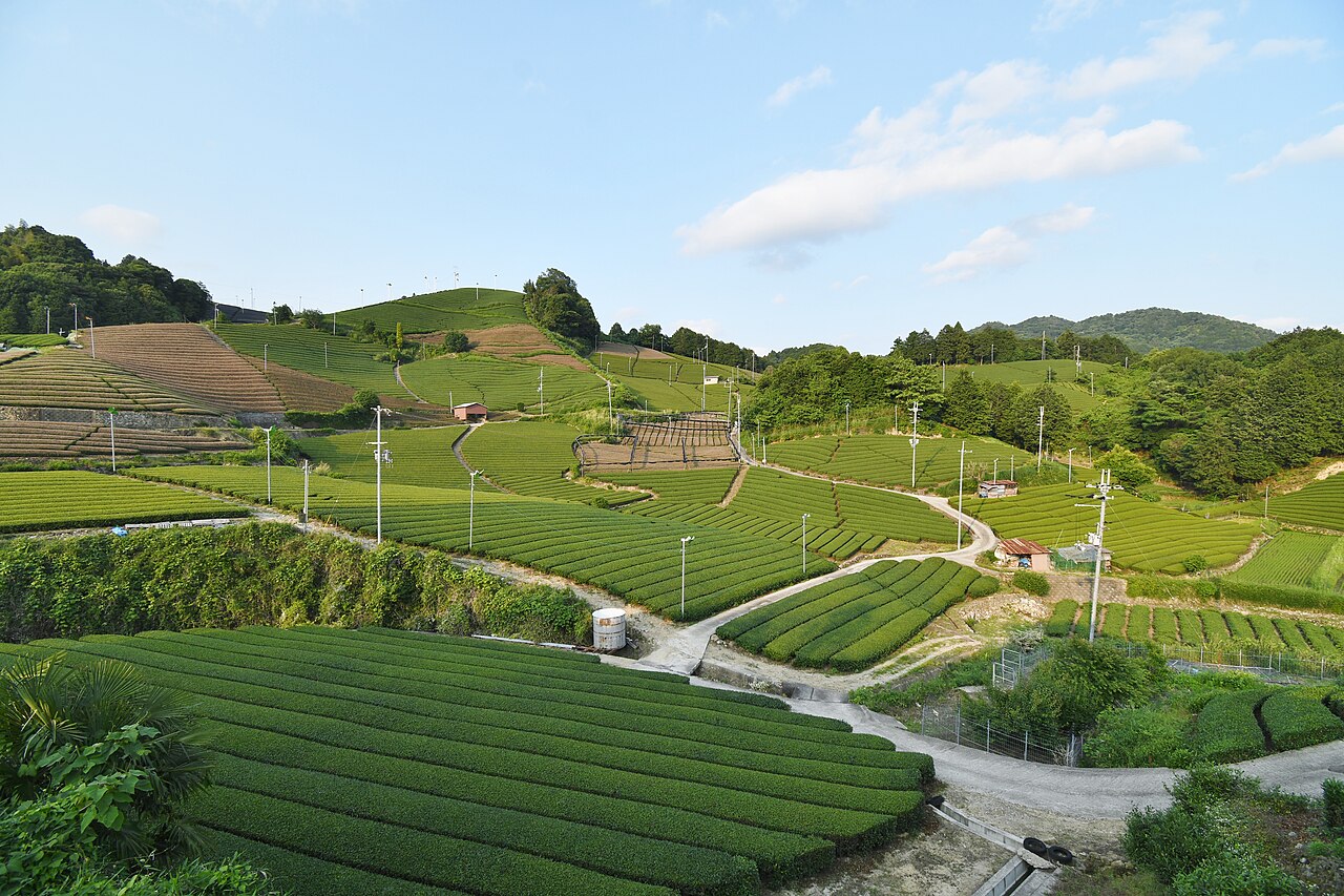
South-east of Kyoto, and a whole world away from the city, lies Wazuka, reached by train to Kamo Station and then a local bus. Here, undulating terraced slopes are lined with rows of verdant tea bushes growing Kyoto’s coveted Uji tea leaves, and around 40% of all Uji tea comes from here. The town has cultivated tea for more than 800 years, and it is part of a Japan Heritage designation that celebrates 800 years of Japanese tea history. The rolling fields reward walkers as much as tea lovers. In the Ishitera tea fields, in the warmer west of the town, picking of the first flush begins by late April. In 2008 the Wazuka tea fields became Kyoto Prefecture Landscape Asset No. 1, the first entry on the prefecture’s list of protected landscapes. Meander along the Wazuka River, climb the hills to take in views of the fields, and hike to Hyakujo-iwa, a massive granite rock in the Kamakura-dani ravine in the east of the town, which is listed among Kyoto Prefecture’s 200 selected natural sites. Local legend says the Zen monk Daikan, founder of nearby Daichi-ji temple, meditated on top of it for 100 days.
Getting there and when to go: Take the train to Kamo Station, then a local bus into Wazuka. Come from late April, when picking of the first flush begins in the Ishitera tea fields, or in autumn when the hillsides are quieter.
3. Mt. Mitoku: Tottori Prefecture

High on Mt Mitoku, through a lush forest, up some chains and ladders, under a maze of temple struts, over rock formations worn by pilgrims past, you will find Nageire-do. For those passionate about hiking in Japan, this temple hall of the Sanbutsu-ji complex, built more than 1,000 years ago and now a National Treasure, is possibly the most bewildering building in the country, perched on stilts up a sheer cliff face. Sanbutsu-ji itself was founded in 706 as a hall for mountain ascetics. It’s also a more than good enough reason to hike up Mt Mitoku to visit. The legend goes that En no Gyoja threw three lotus petals into the wind and instructed them to go to places sacred to the gods, pledging to build temples wherever they may land; one landed on Mt. Mitoku. Nageire-do’s survival would be remarkable enough somewhere stable, but to have remained standing so long on islands regularly beset by earthquakes and typhoons is incredible. Without a doubt, the mountain gods truly care for it. The climb is treated as an act of worship and the temple’s rules are strict. Reception at the start of the trail is open from 8am to 3pm, everyone must be back down by 4.30pm, and solo climbers are turned away, so bring at least one companion. Footwear is checked before you set off: hiking shoes without metal spikes are the safest choice, and anyone whose shoes are refused can rent straw waraji sandals. Adults pay ¥1,200 in total, made up of a ¥400 entry donation and an ¥800 climbing fee. The route usually closes from around December to March because of snow and can also shut in rain.
Getting there and when to go: The climb is open from 8:00am to 3:00pm at the trail reception, and everyone must be back down by 4:30pm. The route usually closes from around December to March for snow and can shut in rain, so go between spring and late autumn with a companion, as solo climbers are turned away.







4. Kumano Kodō Pilgrimage Trail: Mie, Nara and Wakayama Prefectures
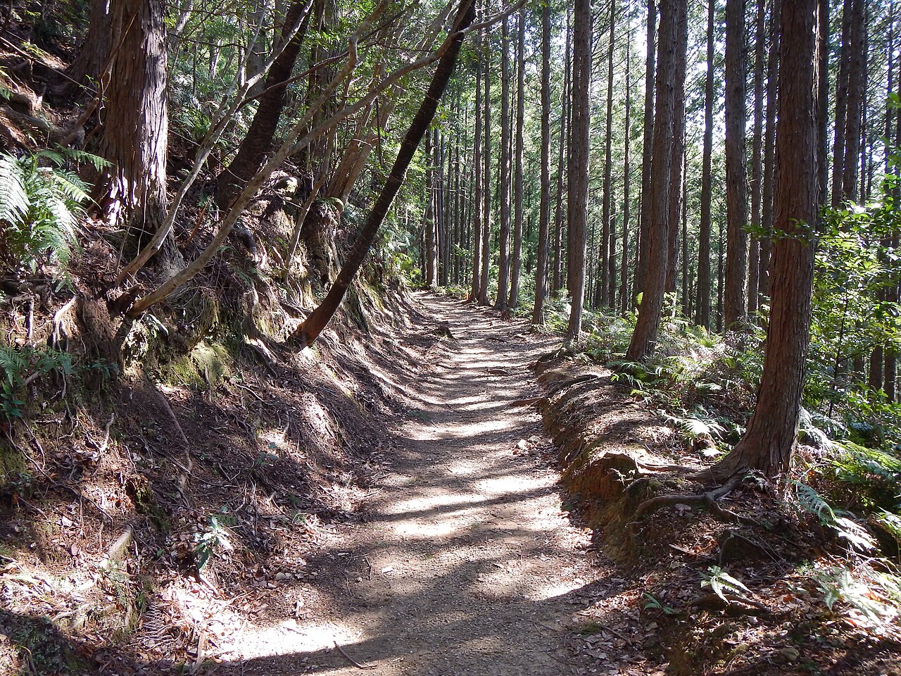
The Kumano Kodo, one of only two UNESCO-registered pilgrimage trails worldwide, follows an ancient trail trod by pilgrims for over 1,000 years through deep forested valleys in remote countryside on the Kii peninsula. Hiking in Japan offers a unique blend of spirituality and adventure, and the Kumano Kodo is a prime example of this. People from all levels of society have followed several different pilgrimage routes to the revered Kumano Sanzan, the three grand shrines of Kumano. The various paths, known collectively as the Kumano Kodo, offer those with an adventurous heart picturesque forests, sweeping mountain views, majestic waterfalls, cobbled ways, and a sense of community. There are many tour operators that provide guided and self-guided options along the different pilgrimage routes such as Walk Japan. Highlights of the hiking trail are the Kumano Hongu Taisha Grand Shrine, the Oyunohara Gate and the Seiganto-ji Temple.
Getting there and when to go: The Kumano Kodo can be walked all year. If you can time it for mid April, the Kumano Hongu Taisha Spring Festival runs from 13 to 15 April, one of the oldest traditions linked to the pilgrimage.
5. The Koyasan Choishi Michi Trail: Wakayama Prefecture

Koyasan is a temple town founded by the monk Kobo Daishi (Kukai) in 816, set on a high plateau ringed by mountains carpeted in cedar forest. A network of ancient pilgrimage trails, exemplifying the best of hiking in Japan, runs through the woodlands and up the mountains, connecting the sacred shrines. One of the most popular hiking trails is the Choishi Michi Trail, named after the stone signposts (choishi) which mark the path so that pilgrims can find their way. There are 180 of these three metre markers, one roughly every 109 metres, and most were carved in the late Kamakura period. From Jison-in Temple the trail heads uphill along a path lined with majestic cedar trees, past Ogo-ike Pond, the stone Futatsu-torii gates and Kesakake-ishi, a rock where Kobo Daishi is said to have hung his robe and rested. The trail is about 21 kilometres long and takes around six and a half hours of walking, or closer to eight with temple stops. Near the end it passes through the Daimon Gate, the 25.1 metre gateway to Koyasan, which has panoramic views of the surrounding mountains.
Getting there and when to go: The trail starts at Jison-in temple at the foot of the mountain and climbs to Koyasan, where you can stay overnight in a temple lodging. Allow around six and a half hours of walking, closer to eight with temple stops, and set off early in winter when daylight is short.
6. Michinoku Shiokaze Coastal Trail: Aomori, Iwate, Miyagi, and Fukushima Prefectures

In ancient times, Japan’s north-eastern Tohoku region was known as ‘Michinoku’, meaning ‘the end of the road.’ Tohoku, one of Japan’s more remote and less developed regions, is an ideal destination for those seeking authentic experiences of hiking in Japan. It offers untamed nature and rugged landscapes, far removed from the bright lights and tourism hubs of Tokyo, Osaka, and Kyoto. The Michinoku Shiokaze Coastal Trail, one of Japan’s longest and newest hiking routes, stretches over 1,000 kilometres through the prefectures of Aomori, Iwate, Miyagi, and Fukushima. The trail was officially completed in 2019 as part of the Tohoku region’s ongoing efforts to rebuild and re-establish the area following the devastating 2011 earthquake and tsunami. The Fudai to Tanohata section of the hike, although challenging, is one of the most memorable. From hand-dug tunnels to the famous cliffs of Kitayamazaki, this is a section not to be missed.
Getting there and when to go: The Fudai to Tanohata section sits on the Iwate coast. Check the Michinoku Coastal Trail website for section closures before you set off.
7. Kunisaki Peninsula: Ōita Prefecture
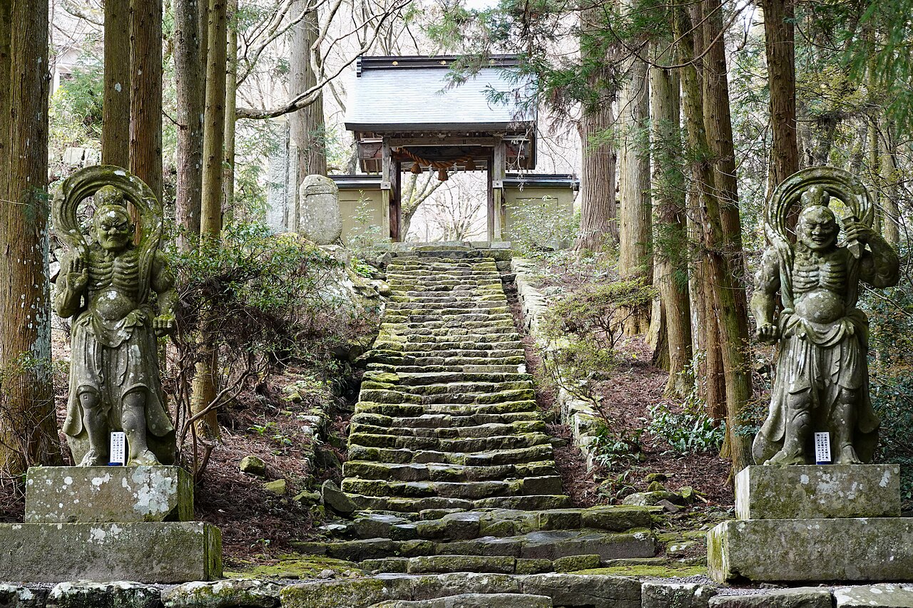
The Kunisaki Peninsula juts out from the north-east coast of Kyushu, the most south-westerly of Japan’s four main islands. But the peninsula may as well have fallen off the map, for few Japanese and even fewer foreigners know of its existence. It was, though, for many centuries the heartland of Rokugo Manzan, a local faith that blended mountain worship, Shinto and Buddhism and took shape in the Nara and Heian periods. Kunisaki’s once-powerful religious institutions are long gone, but delightful temples and wayside shrines are some reminders of its deeply religious past. Explore your spirituality at Futago-ji Temple on the way up Mount Futago, which at 721 metres is the highest point on the peninsula. You can also hike the Kunisaki Peninsula Minemichi Long Trail, around 135 kilometres of mountain paths and old roads split into ten courses, which follows the ridge routes Rokugo Manzan monks once walked for ascetic training.
Getting there and when to go: Oita Airport sits on the Kunisaki Peninsula itself, so the trailheads are within easy reach by hire car. The ten courses can be walked one at a time as day hikes.
8. Daisetsuzan National Park: Hokkaidō Prefecture

If all you want is mountains, then Daisetsuzan National Park is for you. Daisetsuzan means “great snowy mountains,” and the name fits, as Japan’s largest national park boasts more than 16 peaks over 2,000 metres, including Mount Asahidake, the highest in Hokkaido at 2,291 metres. This rugged, beautiful area is known as Kamui-mintara, or “Playground of the gods,” by the Ainu. Patches of snow linger near the summits well into summer, which up here runs only from roughly July to August. Daisetsuzan is a highlight of Hokkaido and a must-visit spot for anyone passionate about hiking in Japan. The main area around the Asahidake Ropeway, a ten minute ride from Asahidake Onsen up to Sugatami Station at 1,600 metres, features vibrant wildflowers, gorgeous alpine lakes, large dramatic peaks, and volcanic terrain complete with steaming gas vents. An adult round trip costs ¥3,500 from June to October and ¥2,800 from November to May. Mt Asahidake, Mt Biei, and Mt Tokachi are the standout summit hikes in the park that are sure to get your heart pumping.
Getting there and when to go: The Asahidake Ropeway leaves from Asahidake Onsen and costs ¥3,500 return from June to October. Hike between roughly July and August, the short alpine summer, when the snow has cleared from the summit trails.
9. Mt. Tanigawa: Gunma Prefecture

Mt. Tanigawa is one of the easiest high mountains to reach from Tokyo. Joetsu Shinkansen trains run from Tokyo Station to Jomo-Kogen Station in around 70 minutes, and a bus from there reaches the ropeway in about 45 minutes. Hikers arriving by local train on the JR Joetsu Line can use Doai Station, a sort-of mini attraction in its own right and often called the deepest station in Japan, with an underground platform about 70 metres below the surface. There is no escalator or lift, and the climb to the exit is nearly 500 steps, so the hiking truly begins when you get off the train. Mt. Tanigawa is the best known peak of an incredibly beautiful mountain range on the Gunma and Niigata border, although the range’s highest summit is neighbouring Mount Sennokura at 2,026 metres. The Tanigawadake Ropeway lifts visitors up to Tenjindaira at 1,319 metres, enabling convenient day trips. It runs from mid April to mid November, and an adult round trip costs ¥3,000. The ropeway doesn’t take away from the excitement though, as the trail that reaches the peak contains a variety of steep terrain features, with chains and ladders to assist with the ascent. It’s stunningly beautiful, with boardwalks, massive boulders, and bamboo grass that resembles waves on a vibrant green ocean. Skipping the ropeway offers an enjoyable hike through the forest to a nearby ridgeline, featuring fixed chains, scenic views, and diverse terrain.
Getting there and when to go: Joetsu Shinkansen to Jomo-Kogen takes about 70 minutes from Tokyo, then a bus of about 45 minutes reaches the ropeway, which runs from mid April to mid November.
10. The Seven Waterfalls of Kawazu: Shizuoka Prefecture

For many people, hiking in Japan is all about enchanting forests, flowing rivers, ancient folklore and beautiful waterfalls. If that’s what you’re after then this seven waterfall hike is likely one of the best in Japan for you. Located on the southern side of Mount Amagi on the Izu Peninsula, the trail is an 850 metre path beside the Kawazu River that links all seven falls and takes about an hour one way. The falls were carved from lava that flowed into the river around 25,000 years ago, and they are now a geosite of the Izu Peninsula UNESCO Global Geopark. The seven falls range in height from 30 metres down to just two, and at Kamadaru, a 22 metre drop, a viewing deck sits close enough to feel the spray. There are hot springs along the way, and at Shokeidaru you’ll find a statue of the dancer from “The Izu Dancer”, the short story by Nobel Prize winning author Kawabata Yasunari that immortalised the area. Buses from Kawazu Station on the Izukyu line take about 25 minutes. This is a relatively easy hike, but one which really captures the beauty and culture of Japan.
Getting there and when to go: Buses from Kawazu Station on the Izukyu line take about 25 minutes. The 850 metre path is walkable all year.
Questions About Hiking in Japan and Climbing Mount Fuji
Every climber pays ¥4,000 on all four trails, a combined toll and entry charge set by Yamanashi and Shizuoka prefectures. You also register online before climbing. Hut beds, transport to the fifth station and gear hire are extra, and anyone without a hut booking cannot start up between 2:00pm and 3:00am.
Only in the official summer season. In 2026 the Yoshida and Subashiri trails opened from 1 July to 10 September, and the Fujinomiya and Gotemba trails from 10 July to 10 September. Outside those dates all trails from the fifth station to the summit are closed.
From this list, the Kawazu Seven Waterfalls on the Izu Peninsula is the gentlest: an 850 metre riverside path linking all seven falls, about an hour one way, with buses from Kawazu Station. Yakusugi Land on Yakushima also has short forest courses starting at 30 minutes.
Some routes, yes. The Kumano Kodo, Koyasan and Kawazu walks stay open all year. High routes close or become mountaineering rather than hiking: Mount Mitoku’s cliff temple usually shuts from around December to March, and Mount Tanigawa’s ropeway stops in mid November.
Yakushima’s forests, where moss-covered cedars in Shiratani Unsuikyo and along the Jomon Sugi trail are often linked to the film’s setting. The island became one of Japan’s first natural UNESCO World Heritage Sites in 1993.
Not for most marked trails. Guides help on Yakushima, where local companies such as Yakushima Experience run English tours, and on multi-day Kumano Kodo routes, where operators such as Walk Japan organise luggage and inns. Mount Mitoku will not let anyone climb alone, so bring at least one companion.


